Current Research Projects
Understanding and mitigating human vulnerability to wildfire to increase resilience (ONGOING)
Increasing wildfire disasters have shown us that the most vulnerable and marginalized populations are the most likely to experience the negative impacts of wildfire. As communities seek to increase their wildfire resilience, and functionally live with wildfire, marginalized and vulnerable populations are often overlooked or misunderstood in terms of their specific needs and challenges. Our lab group is working with communities recently burned in catastrophic wildfires to better understand how they can improve planning and mitigation efforts around the most vulnerable populations to reduce the risk of future wildfire disasters. (Funding from the UC Office of the President Multi-Campus Research Initiative and US Dept of Housing and Urban Development).
Increasing Indigenous-led fire on the landscape (ONGOING)
As catastrophic wildfires increase in size and detrimental outcomes across the globe, many fire managers and communities have begun to ask whether Indigenous burning, practiced widely for millennia across the world, could help solve the problem of catastrophic wildfires. Indigenous groups in California were banned from using cultural fire for over a century, although many defied colonizer laws to continue practicing this form of land stewardship as a birthright responsibility to care for the land. As tribes and colonizer land owners and managers across the west seek to restore widespread cultural burning practices, our team is studying the challenges they face and the complexities of trying to scale up cultural fire in states vastly changed by two centuries of colonization.
Climate impacts on wildfire patterns and management globally (ONGOING)
Climate change impacts on fire ecology and management more broadly are already being observed across much of the US, and are projected to continue and increase in many areas. Part of the challenge for fire and land managers is to both understand and quantify those impacts at multiple scales, and then to utilize climate information in a way that increases the resilience and success of their management programs. We work on projects across the human-environment range from the physical to the social sciences to address this issue. We also conduct considerable outreach developing climate information tools for wildland fire and land managers, and conducting workshops and webinars on using historical and projected climate data in management applications.
Assessing vulnerability and increasing resilience to cascading consequences on wildfire in the Northwest (COMPLETED)
We are working with WSU and a broad range of stakeholders to develop improved modeling of wildfire vulnerability and develop scenarios for increasing resilience through forest management, policy transformation, and community engagement. This is a 4-year effort funded by the NSF Hazard-SEES program for which Dr. Kolden is the PI, you can read more about it by clicking here.
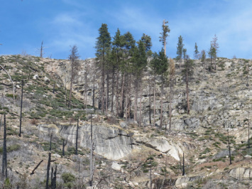
Patterns of wildfire burn severity and unburned islands (COMPLETED)
We are investigating how wildfires burn across the landscape and specifically trying to understand the drivers of unburned islands. These islands occur at different sizes and scales throughout large fires and serve as both critical refugia for wildlife and the seed source for post-fire regeneration. They are also important for mitigating erosion and debris flows post-fire and are part of the patch mosaic that is characteristic of most western US ecosystems. We don't have a good understanding of why they occur where they do, but if we could understand what the drivers of unburned islands are, we might be able to better duplicate them in our attempts to manipulate more fire-resistent and resilient landscapes. This is critical both for preserving threatened and endangered wildlife habitat and other natural resources at risk, and for protecting our homes and communities. We are being supported by the USGS Northwest Climate Science Center for this research.
Burn Severity in bark-beetle killed forests in the central Cascades, Oregon (COMPLETED)
We're partnering with USGS and the USFS Western Wildlands Environmental Threat Assessment Center (WWETAC) to improve quantification of wildfire burn severity in bark beetle-killed forests in the eastern central Cascade mountains. Using a unique LiDAR dataset acquired both pre- and post-fire, as well as field observations and Landsat spectral reflectance, we're working to improve both mapping of burn severity and quantification of biomass consumed and canopy cover lost over the fire. This project takes place on the 2012 Pole Creek Fire on the Deschutes National Forest, and is funded by WWETAC.
Using remote sensing to quantify and monitor changes across landscapes (COMPLETED)
We are working with The Nature Conservancy's Zumwalt Prairie Preserve in northeastern Oregon to quantify and monitor ecological change across their preserve and the adjacent landscape. This includes assessing a reduction in conifer canopy cover through prescribed fire as part of a larger aspen restoration effort, and quantifying grazing impacts on the prairie through multispectral remote sensing. The grazing impacts portion of the partnership is being supported by the TNC Priscilla Bullitt Collins Trust, which has awarded us 5 years' of funding to expand this research into a fully functional decision-support tool that uses remote sensing to map rangeland metrics of vegetation on the ground.
Increasing wildfire disasters have shown us that the most vulnerable and marginalized populations are the most likely to experience the negative impacts of wildfire. As communities seek to increase their wildfire resilience, and functionally live with wildfire, marginalized and vulnerable populations are often overlooked or misunderstood in terms of their specific needs and challenges. Our lab group is working with communities recently burned in catastrophic wildfires to better understand how they can improve planning and mitigation efforts around the most vulnerable populations to reduce the risk of future wildfire disasters. (Funding from the UC Office of the President Multi-Campus Research Initiative and US Dept of Housing and Urban Development).
Increasing Indigenous-led fire on the landscape (ONGOING)
As catastrophic wildfires increase in size and detrimental outcomes across the globe, many fire managers and communities have begun to ask whether Indigenous burning, practiced widely for millennia across the world, could help solve the problem of catastrophic wildfires. Indigenous groups in California were banned from using cultural fire for over a century, although many defied colonizer laws to continue practicing this form of land stewardship as a birthright responsibility to care for the land. As tribes and colonizer land owners and managers across the west seek to restore widespread cultural burning practices, our team is studying the challenges they face and the complexities of trying to scale up cultural fire in states vastly changed by two centuries of colonization.
Climate impacts on wildfire patterns and management globally (ONGOING)
Climate change impacts on fire ecology and management more broadly are already being observed across much of the US, and are projected to continue and increase in many areas. Part of the challenge for fire and land managers is to both understand and quantify those impacts at multiple scales, and then to utilize climate information in a way that increases the resilience and success of their management programs. We work on projects across the human-environment range from the physical to the social sciences to address this issue. We also conduct considerable outreach developing climate information tools for wildland fire and land managers, and conducting workshops and webinars on using historical and projected climate data in management applications.
Assessing vulnerability and increasing resilience to cascading consequences on wildfire in the Northwest (COMPLETED)
We are working with WSU and a broad range of stakeholders to develop improved modeling of wildfire vulnerability and develop scenarios for increasing resilience through forest management, policy transformation, and community engagement. This is a 4-year effort funded by the NSF Hazard-SEES program for which Dr. Kolden is the PI, you can read more about it by clicking here.
Patterns of wildfire burn severity and unburned islands (COMPLETED)
We are investigating how wildfires burn across the landscape and specifically trying to understand the drivers of unburned islands. These islands occur at different sizes and scales throughout large fires and serve as both critical refugia for wildlife and the seed source for post-fire regeneration. They are also important for mitigating erosion and debris flows post-fire and are part of the patch mosaic that is characteristic of most western US ecosystems. We don't have a good understanding of why they occur where they do, but if we could understand what the drivers of unburned islands are, we might be able to better duplicate them in our attempts to manipulate more fire-resistent and resilient landscapes. This is critical both for preserving threatened and endangered wildlife habitat and other natural resources at risk, and for protecting our homes and communities. We are being supported by the USGS Northwest Climate Science Center for this research.
Burn Severity in bark-beetle killed forests in the central Cascades, Oregon (COMPLETED)
We're partnering with USGS and the USFS Western Wildlands Environmental Threat Assessment Center (WWETAC) to improve quantification of wildfire burn severity in bark beetle-killed forests in the eastern central Cascade mountains. Using a unique LiDAR dataset acquired both pre- and post-fire, as well as field observations and Landsat spectral reflectance, we're working to improve both mapping of burn severity and quantification of biomass consumed and canopy cover lost over the fire. This project takes place on the 2012 Pole Creek Fire on the Deschutes National Forest, and is funded by WWETAC.
Using remote sensing to quantify and monitor changes across landscapes (COMPLETED)
We are working with The Nature Conservancy's Zumwalt Prairie Preserve in northeastern Oregon to quantify and monitor ecological change across their preserve and the adjacent landscape. This includes assessing a reduction in conifer canopy cover through prescribed fire as part of a larger aspen restoration effort, and quantifying grazing impacts on the prairie through multispectral remote sensing. The grazing impacts portion of the partnership is being supported by the TNC Priscilla Bullitt Collins Trust, which has awarded us 5 years' of funding to expand this research into a fully functional decision-support tool that uses remote sensing to map rangeland metrics of vegetation on the ground.